
The Red Heart of Australia
Distanz/Distance: 1’595 km
Reisezeit/Travel Time: 02.02.2020 bis/until 14.02.2020
Unterkunft/Accommodation: 2-times free campground and 10-times payed campground /
2-mal gratis Campingplatz und 10-mal gebührenpflichtiger Campingplatz
.
Bei strömendem Regen sind wir im Roten Zentrum von Australien angelangt, doch bereits am nächsten Tag war der Himmel nahezu Wolkenfrei und Stahlblau, wie man es von dieser Wüstenregion erwarten würde. Wie im letzten Post bereits erwähnt, stiessen hier in Alice Springs mein Bruder, Dominic, und seine Freundin, Janine, zu uns um mit uns während den nächsten beiden Monaten den Rest von Australien entdecken. Nachdem wir alles Gepäck welches die Beiden mit sich führten im eher platzarmen Elliot verstaut und organisiert hatten sprachen wir uns ab, was wir als nächstes besichtigen wollten und machten uns auf den Weg in Richtung West Macdonnell Ranges.
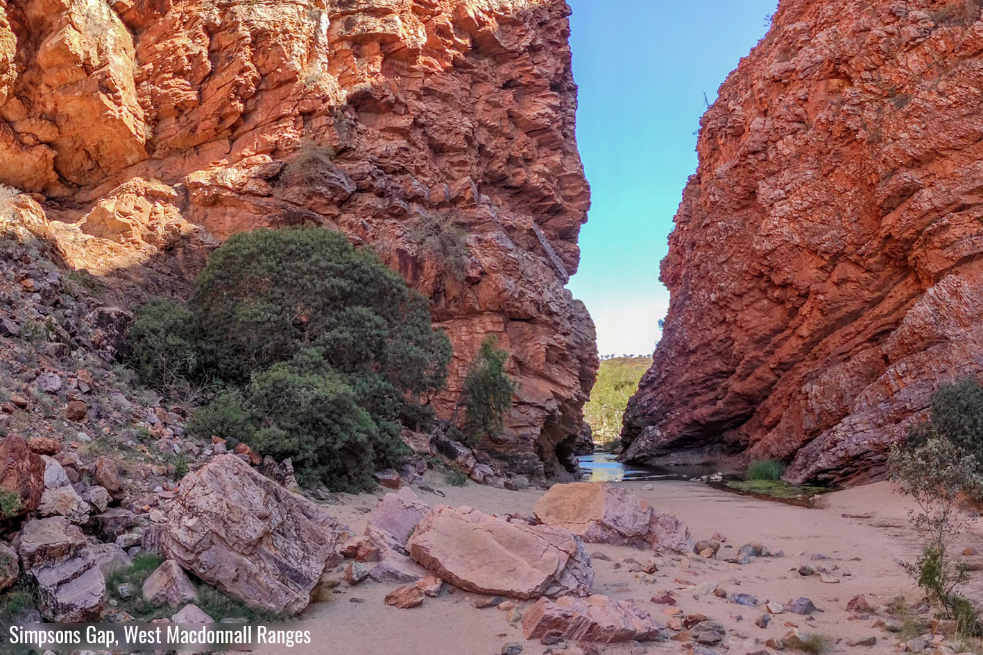
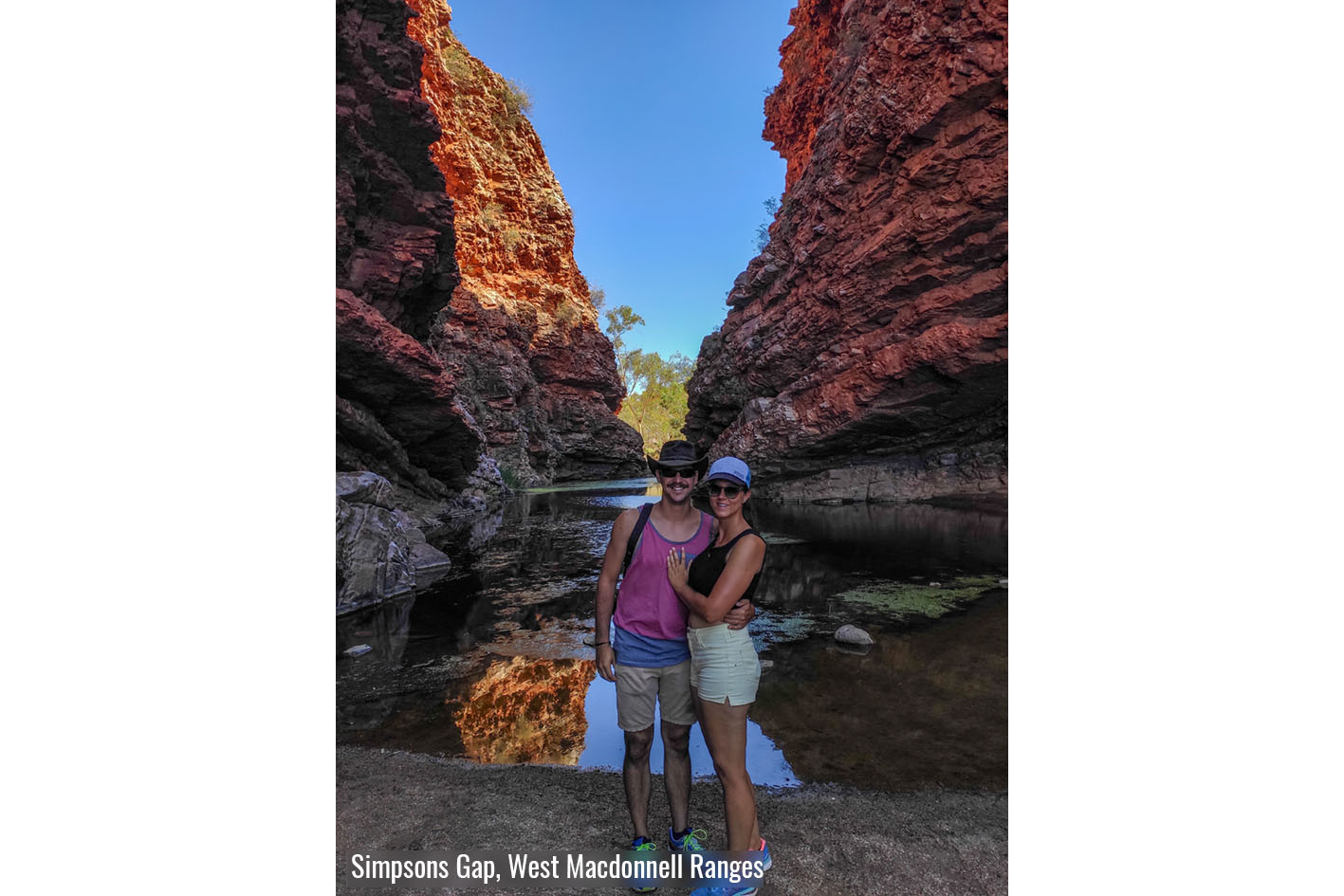
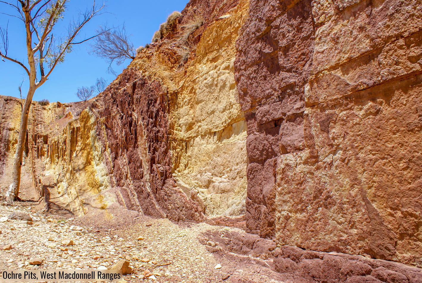
Von Alice Springs aus kann man in einem, eher langen Tag die meisten schönen Orte der West Macdonnell Ranges besichtigen. Unseren ersten Halt machten wir bei der Simpsons Gap. Diese wunderschön rot gefärbte Schlucht mit einem dauerhaft gefüllten Wasserloch gefiel mir unglaublich gut. Dies sicherlich auch da wir relativ früh am Morgen dort ankamen und die Lichtstimmung besonders schön war. Nach einer kurzen Weiterfahrt von 64km besuchten wir das Ellery Creek Big Hole. Hier kann man in einem noch grösseren Wasserloch baden. Leider hatten aber die letzten Regenfälle dort ziemlich viel Schlamm angespült was auf uns nicht wirklich einladend wirkte. Weiter entlang des Namatjira Drive hat man die Gelegenheit Ockervorkommnisse, welche immer noch vom Arrarnta Stamm für Zeremonien und Malereien genutzt werden, zu besichtigen. Diese Ocker Klippen, welche von Weiss über Gelb bis Rot gestreift sind, dürfen von Touristen nicht berührt werden. Jedoch bieten sie ein wunderschönes Motiv für künstlerische Fotos. Nachdem wir an der prallen Sonne bei rund 40 Grad unsere Fotos gemacht hatten, waren wir froh bei unserem nächsten Stopp, der Ormiston Gorge, die Gelegenheit zu haben uns in einem sehr erfrischenden Wasserloch etwas abzukühlen. Vom Wasserloch hat man auch eine sehr schöne Sicht in die Schlucht dahinter. Für mich ist dieser Ort einer der schönsten Plätze welche wir in den West Macdonnell Ranges besuchten. Unseren letzten Halt in den West Macdonnell Ranges machten wir bei der Glen Helen Gorge. Was früher eine Rinderfarm war dient heute als Roadhouse und Pub für Besucher und bietet eine gute Gelegenheit sich mit einem Getränk und Snack zu erfrischen. Ausserdem ist natürlich auch die hohe Sandsteinklippe, welche hinter dem grössten Wasserloch der Gegend aufragt, sehenswert.
Von der Glen Helen Gorge ging es weiter westwärts und dann Richtung Larapinta Drive. Dieser Weg führte uns über den Tylers Pass von wessen Aussichtspunkt aus man eine super Sicht auf den eindrücklichen Gosse Bluff hat. Auf dem Larapinta Drive fuhren wir dann wieder Richtung Alice Springs, um nach einigen Kilometern südwärts auf eine Landstrasse abzubiegen wo das Palm Valley lag. Ein guter Freund von uns empfahl uns einen Besuch in diesem aussergewöhnlichen Tal. Hier wachsen am Ende des Tales zwischen roten Felsklippen, geschützt vom Wind, eine Palmenart, welche man sonst nirgends findet und erst recht nicht in dieser Region der Erde erwarten würde. Da wir an diesem Tag schon so einiges erlebten, fuhren wir erst am späteren Nachmittag von Herrmannsburg durch das Tal bis zum Campingplatz, wodurch die untergehende Sonne eine fantastische Abendstimmung kreierte und alle umliegenden Klippen in den intensivsten Rottönen erscheinen liess. Diese Abendstimmung, im Zusammenspiel mit verschiedensten Flussdurchquerungen, welche Elliot fabelhaft meisterte, machte diesen Abend absolut unvergesslich und zu einem Highlight unserer bisherigen Reise. Am nächsten Morgen fuhren wir die letzten 5km vom Camp aus auf einer ziemlich anspruchsvollen 4×4-Strecke bis zum Palm Valley Wanderweg. Die Wanderung gefiel mir sehr gut, aber die Fahrt bis dort fand ich persönlich noch aufregender. Marco manövrierte Elliot durch ziemlich hohe Steinabsätze und durch unübersichtliche Flussbette, welche Dominic freundlicherweise jeweils zuerst zu Fuss rekognoszierte, sodass wir unversehrt unser Ziel erreichten. Wir waren alle unglaublich erstaunt was unser Elliot alles meistern kann.
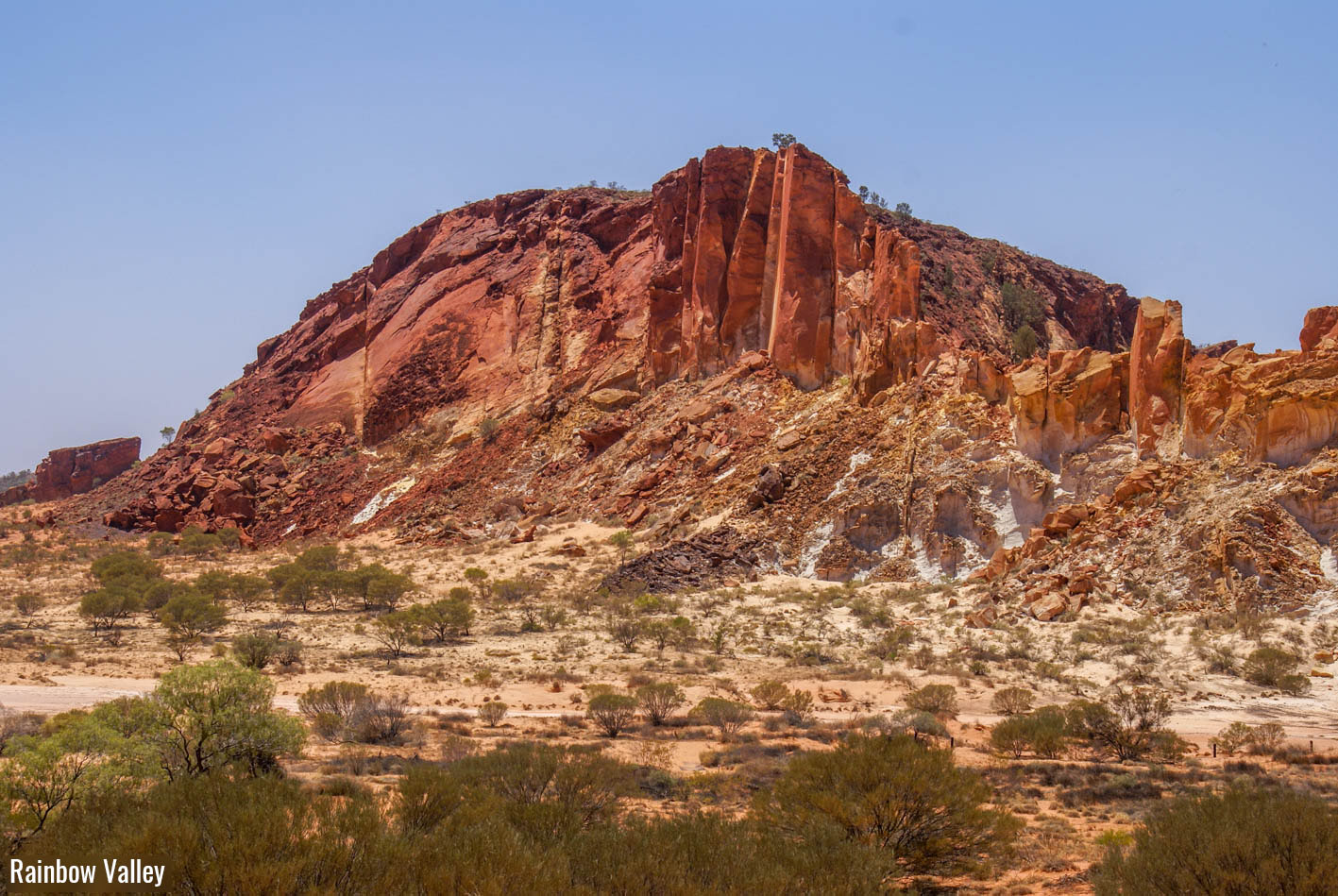
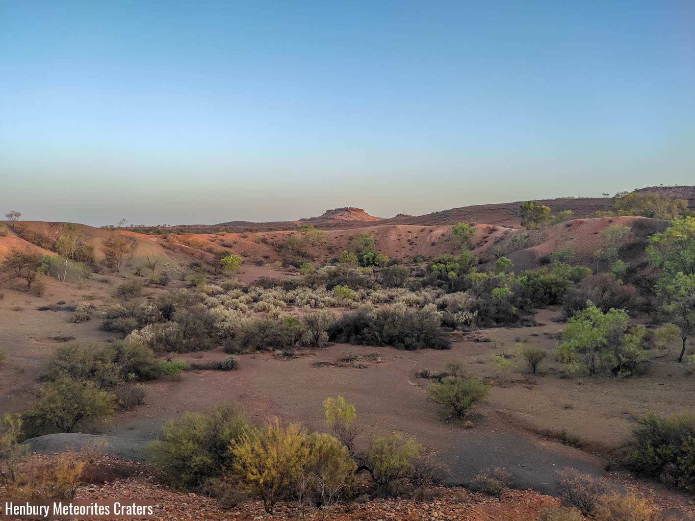
Am Abend nach dem Besuch im Palm Valley fuhren wir zurück nach Alice Springs um unsere Vorräte aufzufüllen und gönnten uns zum Abendessen ein leckeres Bier und super Pizza in der Alice Springs Brewing Company. Am nächsten Morgen machten wir uns auf dem Weg Richtung Yulara, von wo aus man den berühmten Uluru (Ayers Rock) besuchen kann. Unterwegs wollten wir uns jedoch noch ein paar andere Naturspektakel anschauen. Viele Besucher unterschätzen zudem die Distanz zwischen Alice Springs und Uluru und glauben, dass dieser ikonische Berg Australiens in einem Tagestripp besichtigt werden kann. Die Fahrt von Alice Springs bis zum Uluru ist jedoch rund 470km lang und dauert mehr als 5 Stunden. So entschieden wir uns diese Strecke in vier Tagen hinter uns zu bringen und uns am ersten Tag das Rainbow Valley und die Henbury Meteoriten Krater anzuschauen. Das Rainbow Valley ist nicht wie es der Namen glauben lässt ein Tal, sondern ein Berg aus Sandstein, welcher an gewissen Stellen mehr mit Eisen angereichert ist als an anderen. Dadurch und durch das Ausblühen von Mineralien an anderen Stellen strahlen diese Felsen in allen Farbtönen von Weiss bis Dunkelrot und bilden einen schönen Kontrast zum davor liegenden, ausgetrockneten Salzsee. Von dort gingen wir, wie angetönt, weiter zu den Henbury Meteoriten Kratern wo wir uns entschieden die Nacht zu verbringen. Obwohl man in den Kratern eine recht üppige Vegetation vorfindet, welche Nahrung für Vögel und andere Kleintiere bietet, sahen wir leider keinerlei Anzeichen von Leben ausser den allgegenwertigen und überaus lästigen Fliegen. Als wir nach Sonnenuntergang noch beim Camper ein Kartenspiel spielten, hörten wir jedoch in der Ferne einen Dingo heulen was sowohl ein wenig gruselig wie auch mega cool war.
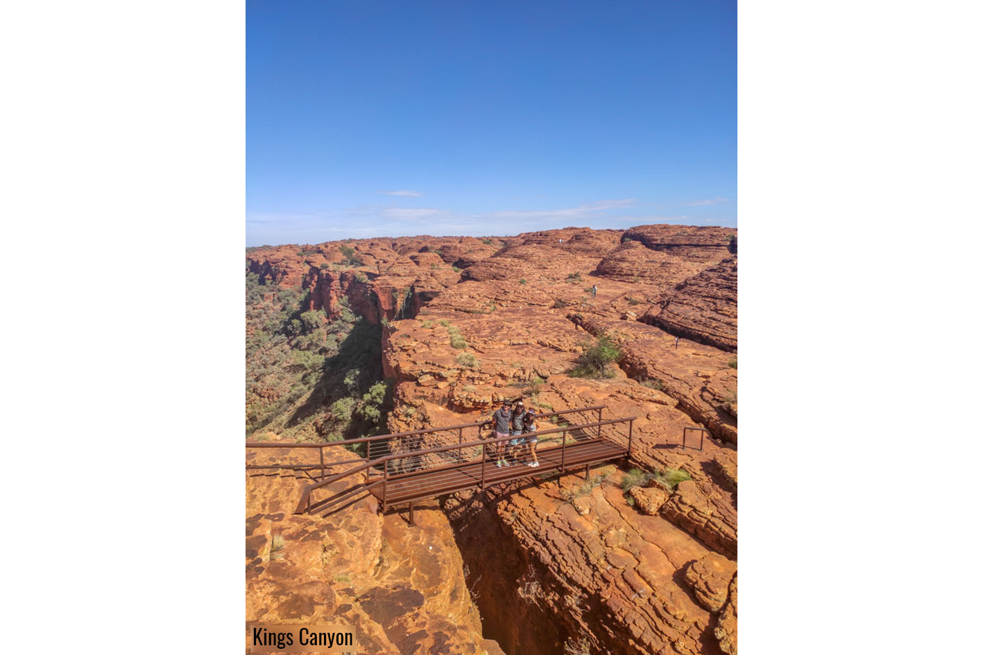
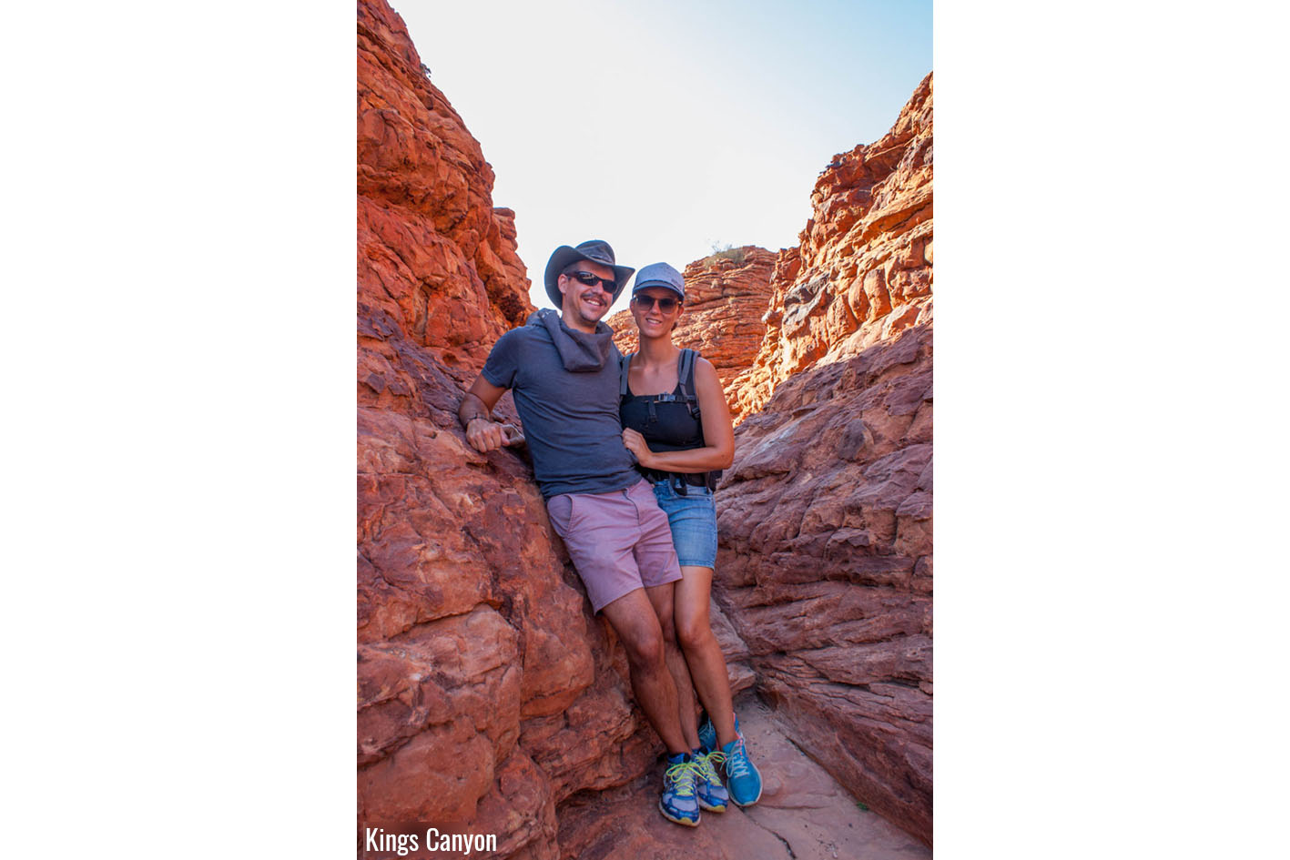
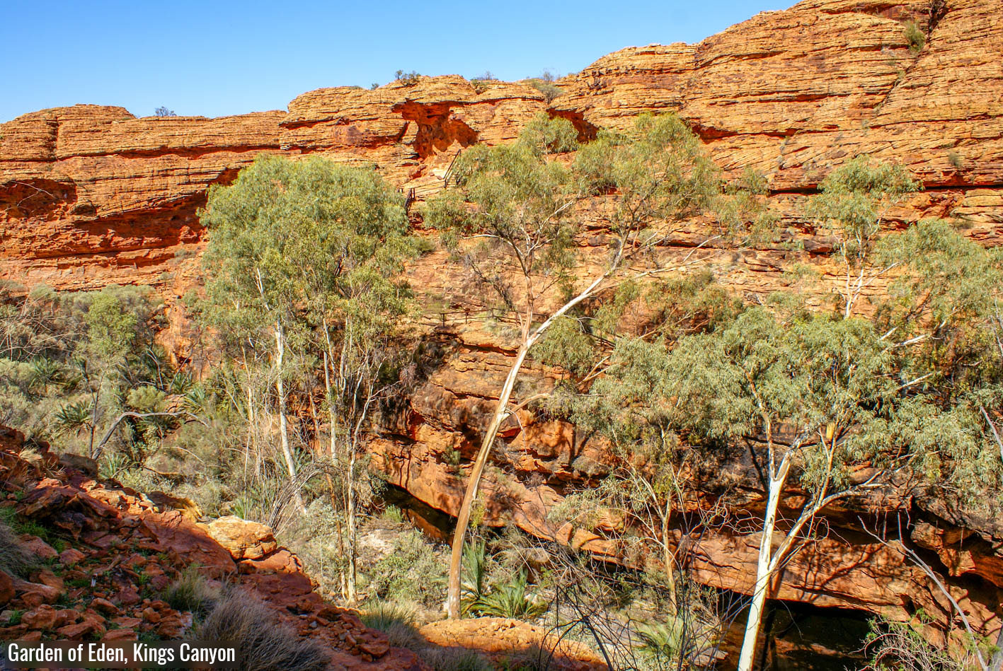
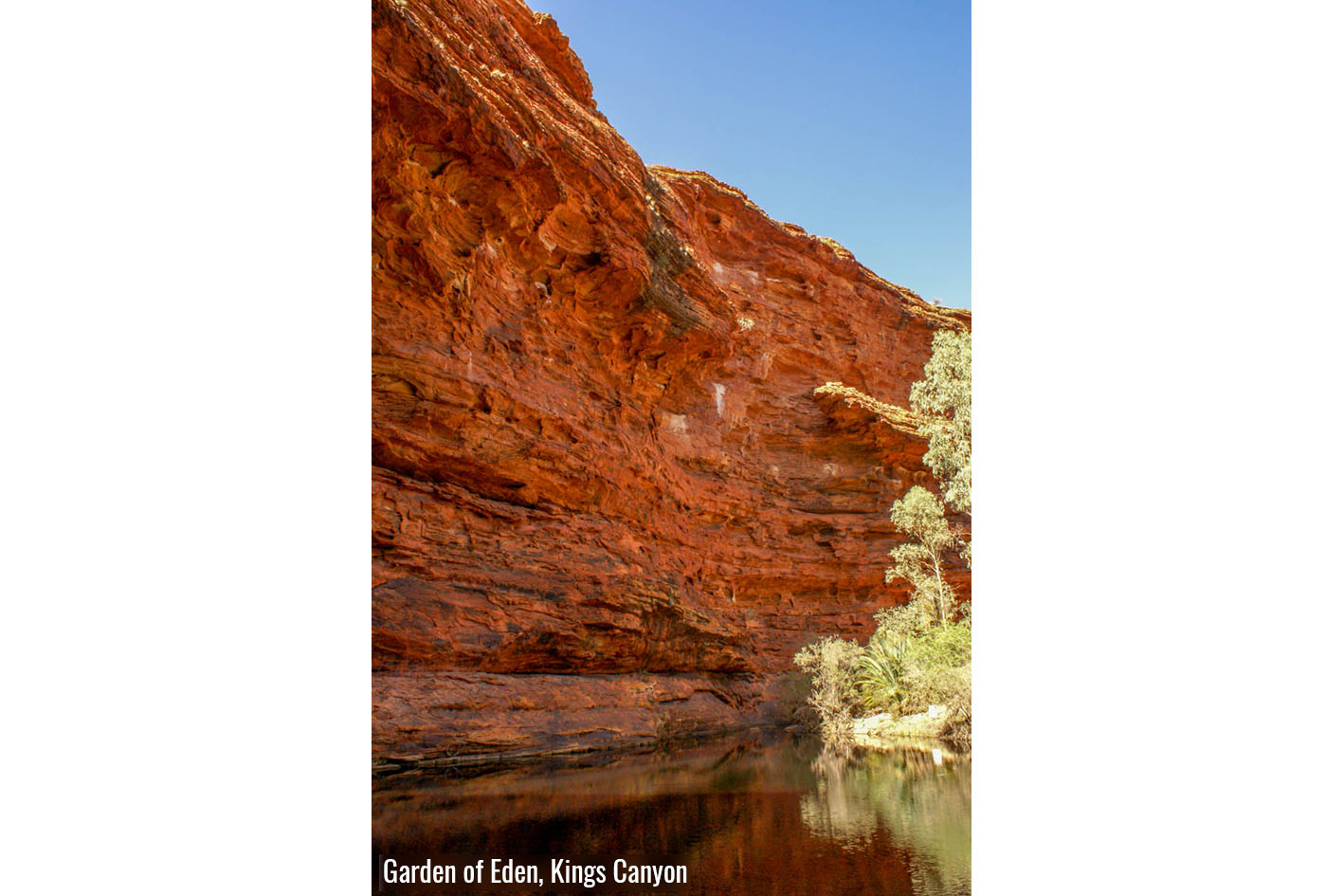
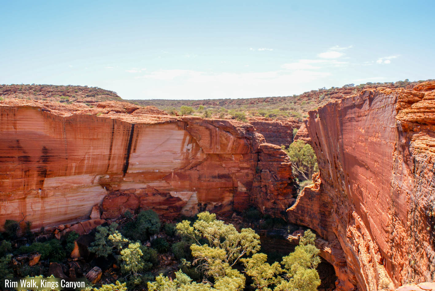
Am nächsten Tag besuchten wir auf unserem Weg Richtung Uluru den Kings Canyon. Dies war etwas vom eindrücklichsten, was wir im Red Centre bis dahin gesehen hatten. Wir machten die 6km lange Rundwanderung, welche bei grosser Hitze ziemlich anstrengend ist. Macht man sich jedoch früh morgens auf den Weg, kann man die drei- bis vierstündige Wanderung sehr geniessen. Nach einem Aufstieg wandert man entlang der atemberaubend hohen und steilen Klippen des sehr eindrücklich geformten Canyons bis zum Garden Of Eden, welches eine wunderschön bewachsene Schlucht mit diversen Wasserlöchern ist. Sobald man die Schlucht betritt kann man überall Vögel zwitschern hören und in den Wasserlöchern kann man viele kleine Frösche beobachten. Der Kings Canyon gefiel mir besonders gut, weil der Garden Of Eden in starkem Kontrast zu der roten und kargen Felslandschaft auf der Klippe des Canyons steht und beide Teile ihre eigene besondere Schönheit haben.
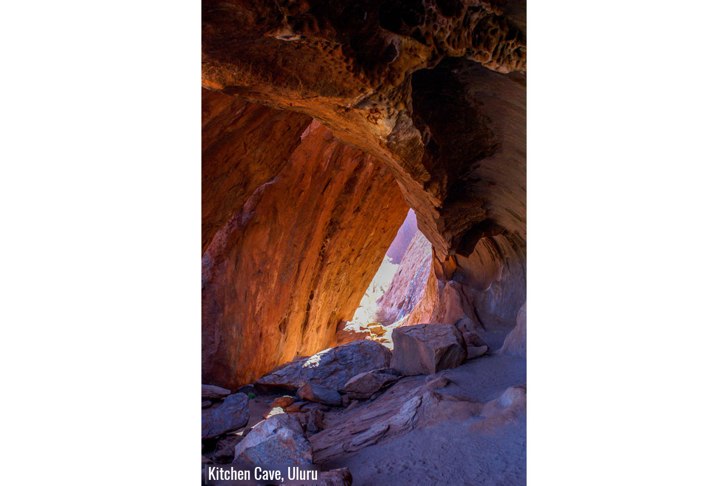
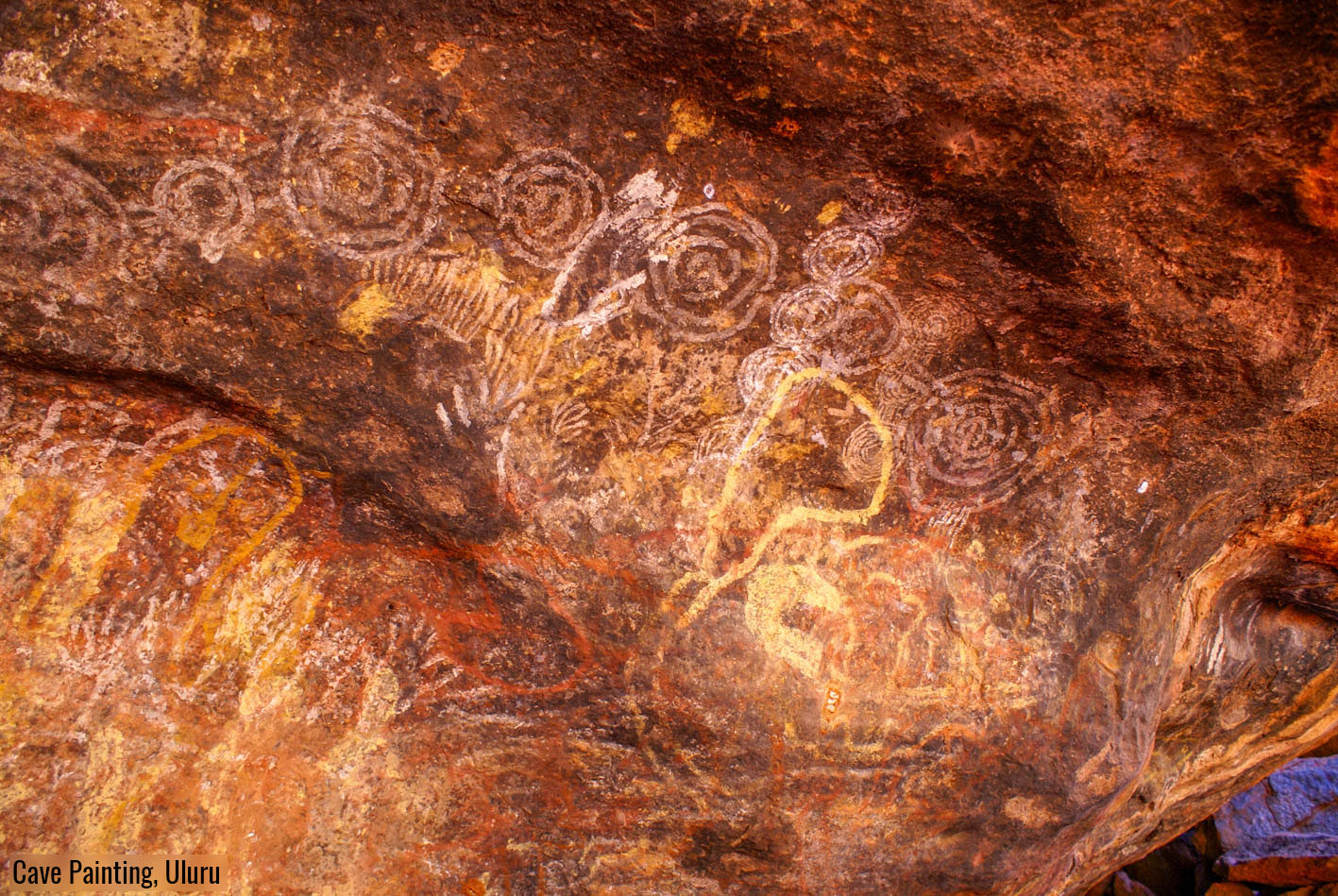
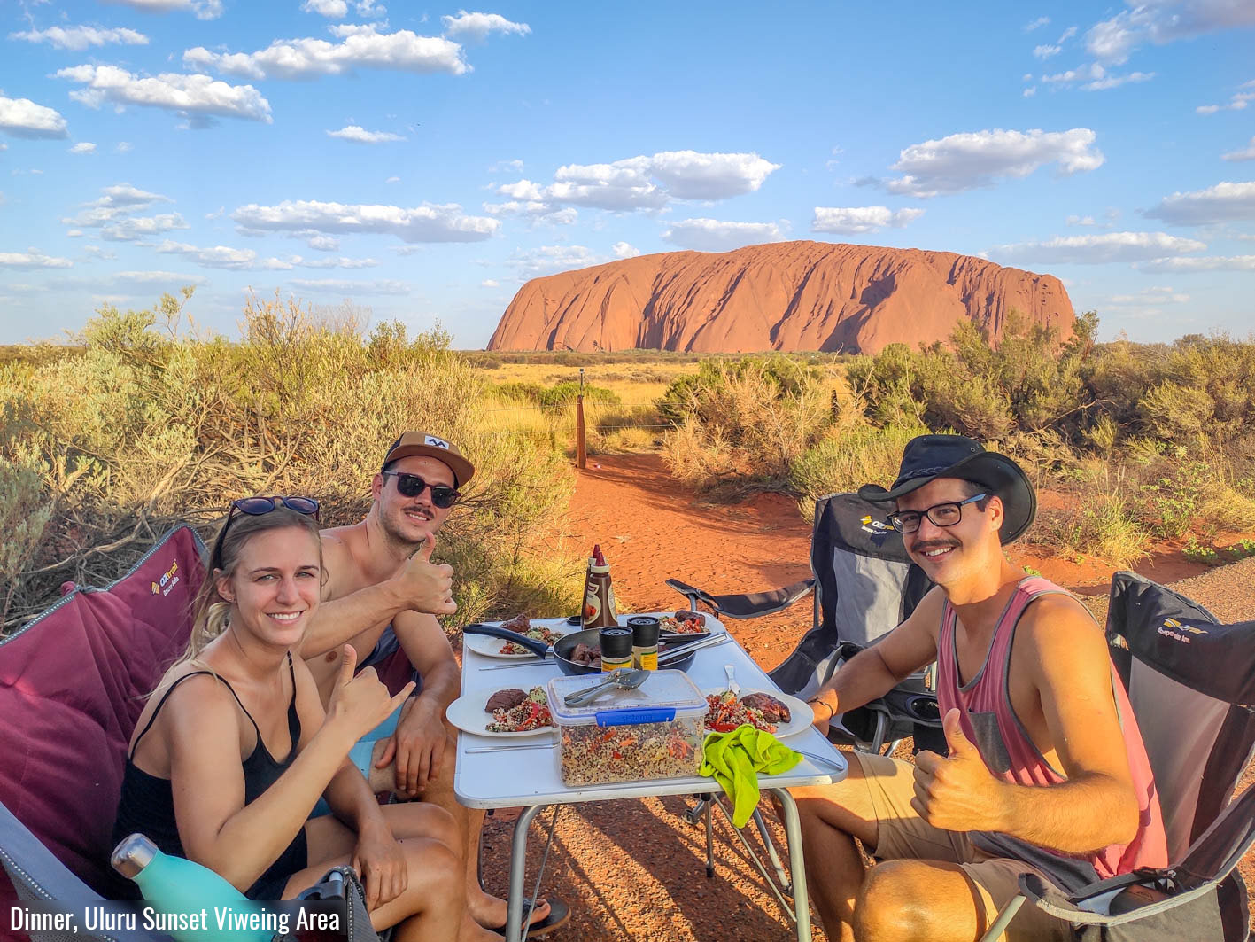
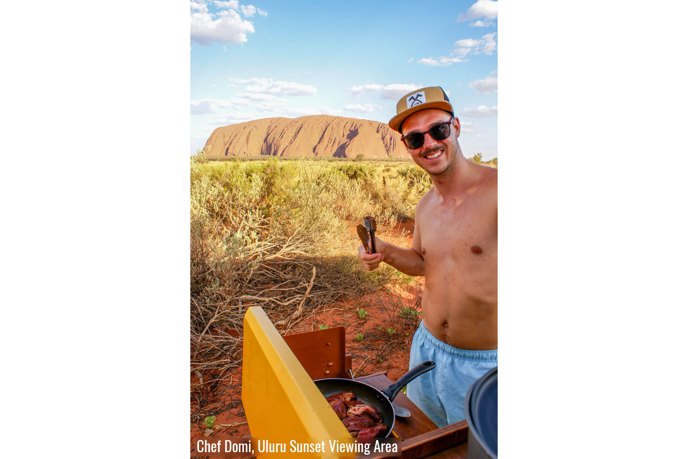
Nachdem wir den Kings Canyon verliessen, verbrachten wir eine letzte Nacht im Curtin Springs Roadhouse, welches auch eine Rinderfarm ist und den eindrücklichen Mount Conner zu ihrem Besitz zählen darf, erreichten wir Yulara. Nachdem wir uns mit Proviant für die nächsten Tage eingedeckt hatten genossen wir erst einmal eine Erfrischung im Pool. Wir buchten drei Nächte auf dem Campingplatz in Yulara, was uns genügend Zeit liess um den Uluru (Ayers Rock) und die Kata Tjuta (Olgas) zu besichtigen. Am ersten Tag besuchten wir als erstes die Sunrise-Viewing-Area um uns das Farbspiel des Umgebungslichtes am Uluru während des Sonnenaufgangs anzuschauen. Im Anschluss schlossen wir uns einem von einem Aborigine geführten Spaziergang in die Kantju Schlucht, einer Spalte in der Nordseite des Ulurus an. Durch den Ranger erfuhren wir über die Geschichte vom Uluru und was die verschiedenen Höhlen, welche wir unterwegs sahen, für die Aboriginals bedeuteten. Er erzählte uns auch von den Tieren, welche um den Uluru leben, und wie die Aborigines früher dort Kängurus jagten. Diese gratis Führung war wirklich informativ und sehr empfehlenswert. Bevor wir uns wieder auf den Rückweg machten stoppten wir noch beim Culture Centre wo der Zufall es wollte, dass wir rechtzeitig dort waren um an einer weiteren Gratisführung von zwei jungen Aborigines teil nehmen zu können. Die beiden Brüder erklärten uns, wie Spere und andere Waffen gefertigt und genutzt wurden und noch heute in traditioneller Lebensweise genutzt werden. Es war für beide die erste Präsentation und man merkte Ihnen die Närvosität an. Dies war für uns sehr verständlich da Englisch nicht ihre Muttersprache ist und sie diese erst in fortgeschrittenem Alter lernten. Nichtsdestotrotz gaben Sie uns einen guten Einblick in Ihre Kultur und wir schätzen es sehr, dass Sie den Mut hatten und sich die Zeit genommen haben uns vom traditionellen Leben in Ihrem Stamm zu erzählen.
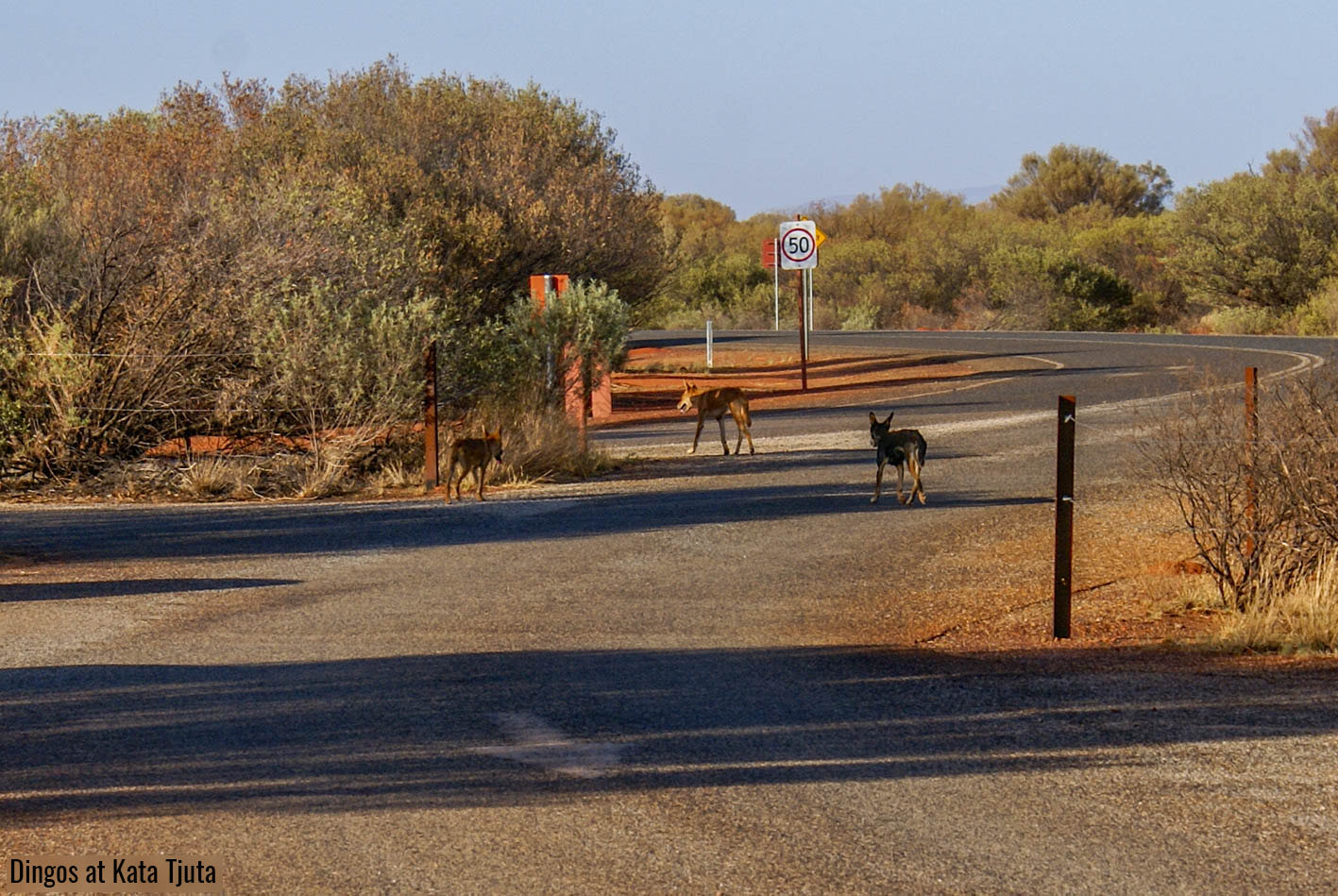
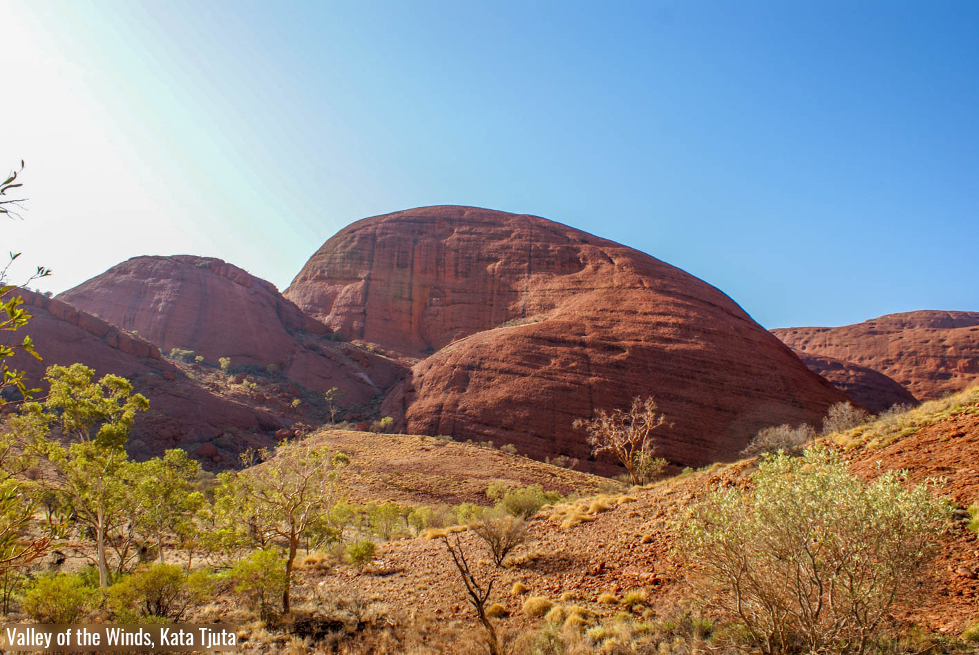
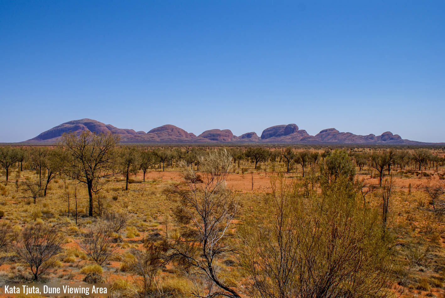
Der zweite Tag beim Uluru / Kata Tjuta Nationalpark nutzten wir um uns die Kata Tjuta (Aborigine für «viele Köpfe») anzuschauen. Wir machten uns wieder vor Sonnenaufgang auf den Weg, da wir eine grosse Wanderung durch die Kata Tjuta machen wollten und es zu dieser Jahreszeit schlicht zu heiss ist, um sich am Nachmittag körperlich zu betätigen. An diesem Morgen hatten wir endlich wieder etwas mehr Glück in Bezug auf Wildtiersichtung, wir sahen nämlich beim Parkplatz, von wo aus die Wanderung startete, drei Dingos. Nach dieser Sichtung machten wir uns gut gelaunt auf den rund 7km langen Rundweg, welcher einem durch die Schluchten zwischen den ründlichen, roten Bergen führt. Wir genossen die Wanderung, müssen jedoch gestehen, dass der Teil nach dem zweiten Aussichtspunkt nicht mehr ganz so spektakulär und durch die zunehmende Hitze auch etwas anstrengend war. Leider hielt auch unser Glück nicht an und wir sahen keine der dort heimischen Rockwallabies. Auf dem Rückweg hielten wir noch bei der Dune-Viewing-Area, von wo aus man eine schöne Fernsicht auf die Felsbröcke der Kata Tjuta und den weiter entfernten Uluru hat.
Den letzten Tag unseres 3-tages Nationalparkpass nutzten wir lediglich, um durch den Park in Richtung West Australische Grenze zu fahren, da die einzige Strasse von Yulara dorthin durch den Nationalpark führte. Hier beginnt unser nächstes Abenteuer: die Durchquerung des Outbacks entlang der Great Central Road zur Grenze von Western Australia und weiter durch sehr abgelegene Landschaften bis wir wieder in zivilisierte Regionen stossen. Lest darüber in unserem nächsten Beitrag.
With pouring rain we arrived in the Red Centre of Australia, but already the next day the sky was almost cloudless and steel blue, as one would expect from this desert region. As mentioned in the last post, here in Alice Springs my brother, Dominic, and his girlfriend, Janine, joined us to discover the rest of Australia with us during the next two months. After we had stowed and organized all the luggage they carried with them in the rather small Elliot, we decided what we wanted to see next and headed towards the West Macdonnell Ranges.
From Alice Springs you can visit most of the beautiful places of the West Macdonnell Ranges in one, rather long day. We made our first stop at the Simpsons Gap. I really liked this beautiful red coloured gorge with a permanently filled waterhole. This certainly also because we arrived there relatively early in the morning and the light was especially nice. After a short drive of 64km we visited the Ellery Creek Big Hole. Here you can swim in an even bigger waterhole. Unfortunately, the last rainfalls had washed up a lot of mud there, which made it not really inviting for us to swim. Further along Namatjira Drive you have the opportunity to see ochre deposits, which are still used by the Arrarnta tribe for ceremonies and paintings. These ochre cliffs, which are striped from white to yellow to red, must not be touched by tourists. However, they offer a beautiful motif for artistic photos. After we took our photos in the blazing sun at about 40 degrees, we were happy to have the opportunity to cool down in a very refreshing waterhole at our next stop, the Ormiston Gorge. From the waterhole you also have a very nice view into the gorge behind it. For me this place is one of the most beautiful places we visited in the West Macdonnell Ranges. Our last stop in the West Macdonnell Ranges was at Glen Helen Gorge. What used to be a cattle farm is now a roadhouse and pub for visitors and a good place to refresh yourself with a drink and a snack. Also, worth seeing is the high sandstone cliff that rises behind the largest waterhole just next to the roadhouse.
From Glen Helen Gorge we continued westwards and then headed towards Larapinta Drive. This trail led us over Tylers Pass from whose viewpoint you have a great view of the impressive Gosse Bluff. On Larapinta Drive we drove again towards Alice Springs and after a few kilometers we turned south on a country road where the Palm Valley was located. A good friend of us recommended a visit in this extraordinary valley. Here, at the end of the valley, between red cliffs, protected from the wind, grows a palm tree species, which you won’t find anywhere else and even less expected in this region of the world. Since we already experienced a lot on this day, we drove from Herrmannsburg through the valley to the camping site only in the late afternoon, whereby the setting sun created a fantastic evening mood and let all surrounding cliffs appear in the most intensive red tones. This evening vibe, in combination with various river crossings, which Elliot mastered fabulously, made this evening absolutely unforgettable and a highlight of our journey so far. The next morning we drove the last 5km from camp on a pretty challenging 4×4 track to the Palm Valley hiking trail. I liked the hike very much, but personally I found the drive to there even more exciting. Marco maneuvered Elliot through rather high stone heels and through unclear riverbeds, which Dominic kindly observed first on foot, so that we reached our destination unharmed. We were all incredibly amazed at what our Elliot could master.
In the evening after the visit in Palm Valley we drove back to Alice Springs to refill our supplies and had a delicious beer and great pizza for dinner at the Alice Springs Brewing Company. The next morning, we started our way to Yulara, from where you can visit the famous Uluru (Ayers Rock). But on the way we wanted to see some other natural spectacles. Moreover, many visitors underestimate the distance between Alice Springs and Uluru and believe that this iconic mountain of Australia can be visited in a day trip. But the drive from Alice Springs up to Uluru is approximately 470 km long and takes more than 5 hours. Thus, we decided to complete this stretch in four days and in the first day we visited the Rainbow Valley and the Henbury Meteorite Crater. The Rainbow Valley is not a valley as the name suggests, but a mountain of sandstone, which in some places is more enriched with iron than in others. Because of this and the blooming of minerals in other places, these rocks shine in all shades from white to dark red and form a beautiful contrast to the dried out salt lake in front of them. From there we went on, as mentioned, to the Henbury Meteorite Craters where we decided to spend the night. Although the craters are covered with lush vegetation which provides food for birds and other small animals, we saw no signs of life except for the omnipresent and annoying flies. When we played a card game at the camper after sunset, we heard a dingo howling in the distance which was both a little creepy and very cool.
The next day, we visited the Kings Canyon on our way to Uluru. This was one of the most impressive things we had seen in the Red Centre until then. We did the 6km long circular hike, which is pretty exhausting in the heat. But if one starts early in the morning, you can enjoy the three to four hours hike very much. After an ascent you hike along the breathtakingly high and steep cliffs of the very impressively formed canyon to the Garden Of Eden, which is a beautifully overgrown canyon with various water holes. As soon as one enters the canyon, you can hear birds chirping everywhere and in the water holes one can watch many small frogs. I especially liked the Kings Canyon, because the Garden Of Eden stands in strong contrast to the red and barren rock landscape on the cliff of the canyon and both parts have their own special beauty.
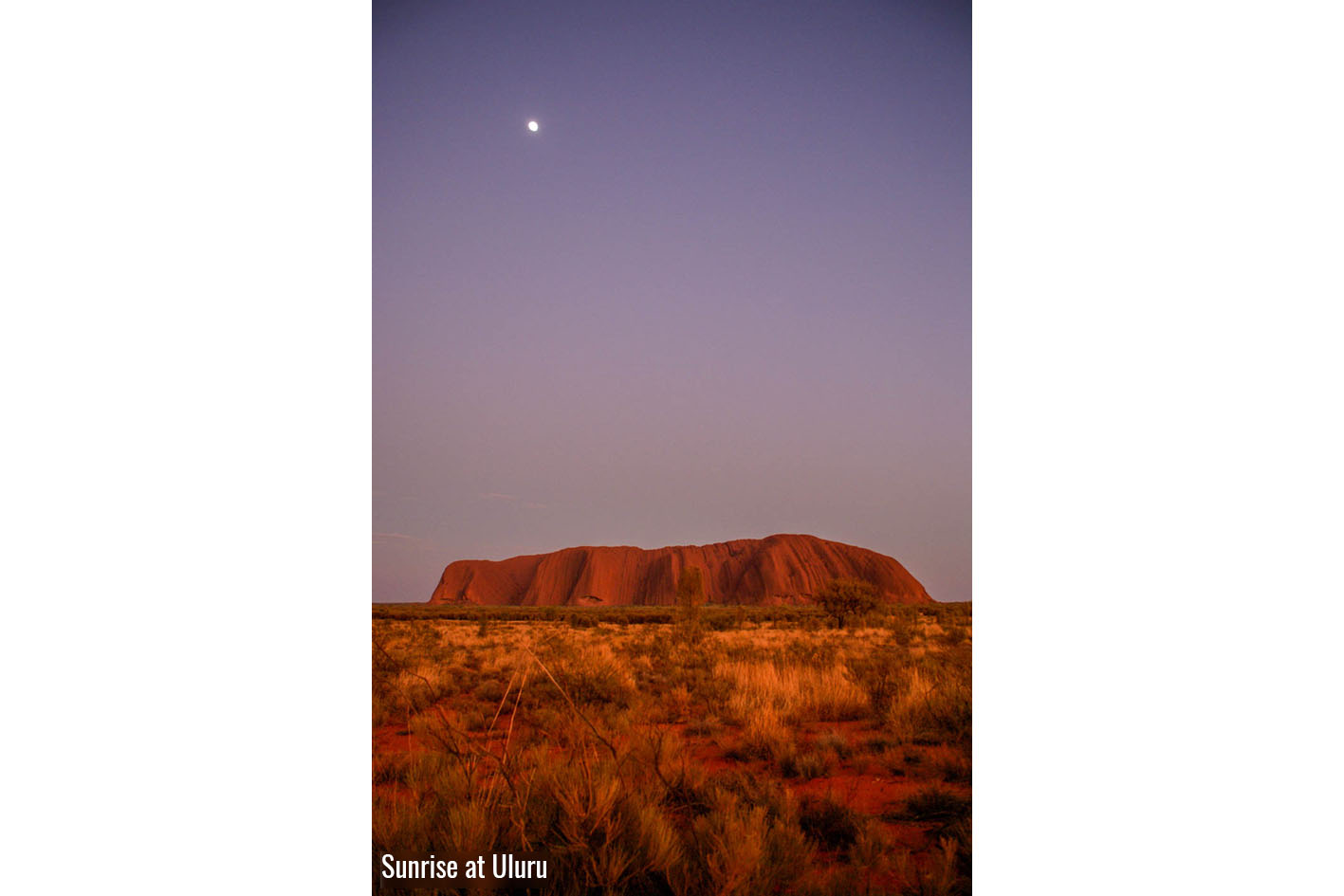
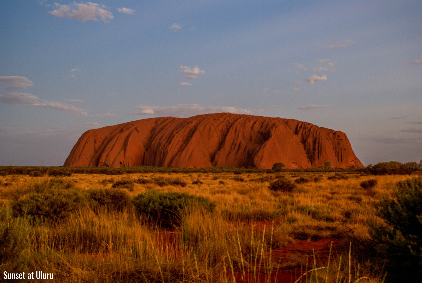
After leaving Kings Canyon we spent a last night at the Curtin Springs Roadhouse, which is also a cattle farm and has the impressive Mount Conner as its property, before we reached Yulara. After we stocked up with food at the shops in Yulara for the next days we enjoyed a refreshment in the pool. We booked three nights at the campground, which gave us enough time to visit the Uluru (Ayers Rock) and the Kata Tjuta (Olgas). On the first day we started with visiting the Sunrise Viewing Area in order to see the colour play of the surrounding light at Uluru during the sunrise. Afterwards, we joined a walk guided by an aborigine into the Kantju Gorge, a crevice at the northern side of the Uluru. Through the ranger, we learned about the history of Uluru and what the different caves, that we saw on the way, meant for the Aboriginals. He also told us about the animals that live around the Uluru and how the Aborigines used to hunt kangaroos there. This free guided tour was really informative and highly recommendable. Before we started our way back we stopped at the Culture Centre where by coincidence we were in time to take part in another free guided tour of two young Aborigines. The two brothers explained to us how spears and other weapons were made and used and are still used today in traditional ways. It was the first presentation for both of them and you could feel their nervousness. This was very understandable for us as English is not their mother tongue and they only learned it at an advanced age. Nevertheless, they gave us a good insight into their culture and we appreciate that they had the courage and took the time to tell us about the traditional life in their tribe.
The second day at Uluru / Kata Tjuta National Park we used to have a look at the Kata Tjuta (Aborigine for “many heads”). We set off again before sunrise, because we wanted to do a big hike through the Kata Tjuta and it is simply too hot at this time of the year to be physically active in the afternoon. On this morning we finally had a little more luck regarding wildlife sighting, we saw three dingoes at the parking lot, from where the hike started. After this sighting we started in a good mood on the approximately 7km long circular trail, which leads you through the canyons between the round, red mountains. We enjoyed the hiking tour, but we have to admit that the part after the second lookout was not so spectacular and due to the increasing heat also a little exhausting. Unfortunately, also our luck did not stop and we did not see any of the rock wallabies that are native there. On the way back, we stopped at the Dune Viewing-Area, from where one has a nice view to the rock boulders of the Kata Tjuta and the further distant Uluru.
We only used the last day of our 3-day national park pass to drive through the park towards the West Australian border, as the only road from Yulara led there through the national park. Here our next adventure begins: crossing the outback along the Great Central Road to the border of Western Australia and further through very remote landscapes until we reach civilized regions again. Read about it in our next post.
Sorry, the comment form is closed at this time.